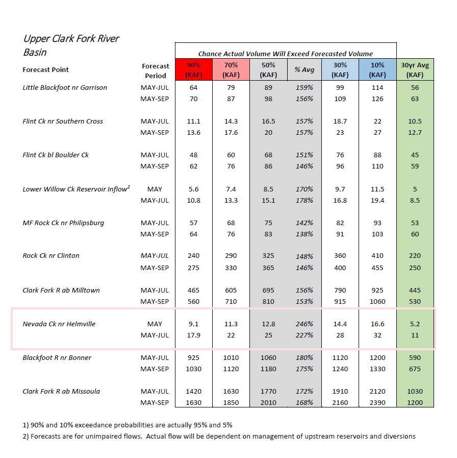
The NRCS has released the Water Supply Outlook Report for May. The full statewide report can be downloaded/viewed here (70 MB). Nevada creek above the reservoir has a most likely projection of 246% of average flow for the month of May, and 227% of average for the period of May through July. This equates to a daily average Nevada creek inflow to the reservoir of 215 cfs for May, and with the typical additional inflows of Buffalo gulch & Indian creek, would equal a total projection of ~260 cfs average inflow through the month of May. Of course, weather conditions will control the actual rate of the runoff on a daily basis.
from the report:
Upper Clark Fork River Basin
This will most certainly go down as one of the biggest snow years in the Upper Clark Fork River basin when looking at basin-wide snowpack. While the latter half of April was warm and dry, the first two weeks brought abundant precipitation to the basin. Most SNOTEL sites had already reported above normal April monthly totals by mid-month. This only continued to build on the well above normal snowpack in the basin and kept snowpack totals at very high to record levels for May 1st. Snow Water Equivalent (SWE) peaked across the basin at low elevations in the first two weeks of the month, and at higher elevations during the last 10 days of the month. Two SNOTEL sites in the basin set new records for peak SWE this year, Nevada Ridge SNOTEL in the Blackfoot River basin and Warm Springs SNOTEL in the Flint/Upper Clark River basin. Two other sites in the headwaters of the basin were the second highest on record, lagging only behind 1975 for peak SWE. Even though melt has begun, many sites remain record high (3 sites) or second highest on record (3 sites) for May 1st, and all measurement locations remain well-above normal for snowpack on this date. Putting statistics aside, what does this mean for water users in the basin? Snowmelt has already caused significant increases in rivers and streams across the region, in some places flooding is already being reported at the time of this publication. The amount of snow remaining in the mountains will continue to feed the rivers and streams and it is yet to be determined when peak flows will occur and how high they will be. There is potential for very high flows this year due to the snowpack. May 1st NRCS forecasts for the May 1st – July 31st period are above average for all streams in the basin, meaning the total volume of water this year will be very high, but the day-to-day and week-by-week flows will depend on future weather. A close eye should be kept on the weather patterns, with two major patterns that could increase flows substantially over a short period of time. 1) Prolonged periods of sunny weather with above average daily temperatures, and above freezing temperatures at night. 2) Rain-on-snow, or prolonged rain events. Water users are highly encouraged to monitor National Weather Service forecasts for their locations and keep an eye on the sky over the next two months.
