April 2018 Water Supply Outlook Report
The N.R.C.S. has released the Montana W.S.O.R. for April, 2018. It can be viewed / downloaded here (70 MB).
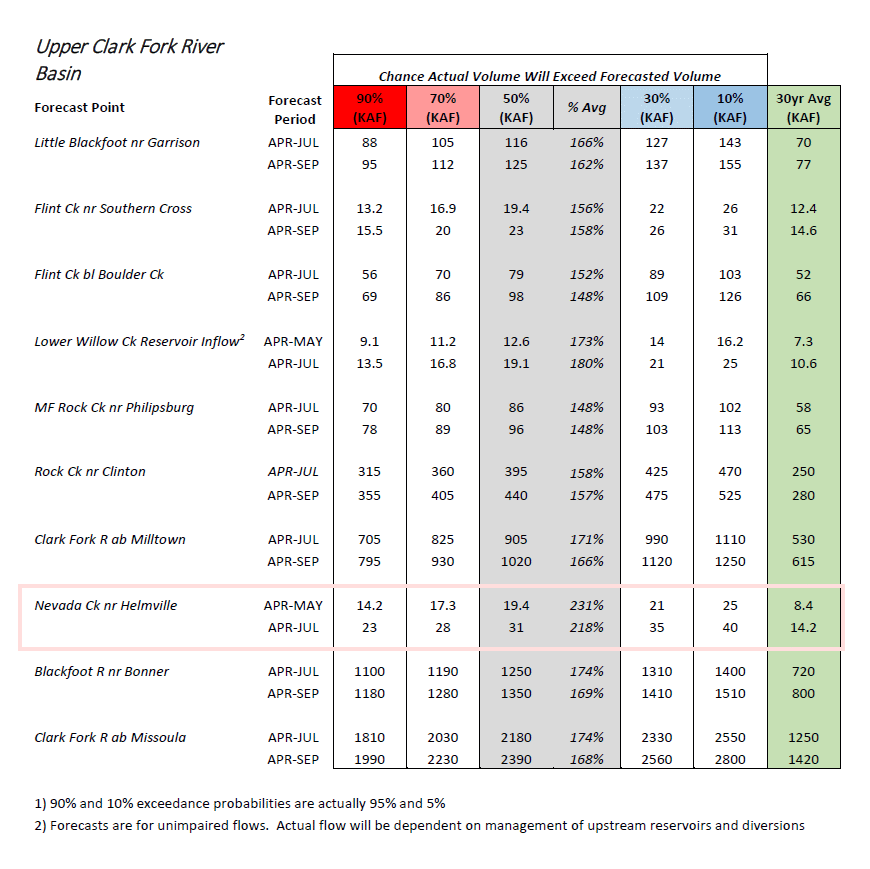
The Nevada creek flow forecast is now for 231% of normal for the April – May period, and 218% of normal for April – July. On a percentage of normal basis, this puts us at the highest projected flows in the state of Montana, and also the western U.S.
from the report…
Upper Clark Fork River Basin
At this point, it should be no surprise to residents of the Upper Clark Fork River basin that this winter has brought a significant amount of precipitation. March was actually near average, but overall precipitation has been well above average since October 1st. This has resulted in record amounts of snow in some parts of the Upper Clark Fork River basin. Currently, all NRCS snow sites have a well above normal snowpack, and many of the basin’s sites have a record snowpack for today’s date. That includes both the low and high elevation sites. Ten Mile Creek Lower Snow Course has its deepest snowpack in 83 years of record. Frohner Meadows SNOTEL south of Helena currently has nearly double the amount of snow water it typically peaks at in mid-April. The snowpack in the basin is currently trending similar to big years such as 1997, 2011, 2014, and is most similar to conditions in 1982. The basin’s highest overall snowpack recorded in history occurred in late April of 1982. This will no doubt be a big runoff year in the Upper Clark Fork River basin. As of April 1st, streamflows are forecasted to be significantly above average this season. The timing of runoff and volume will depend on day-to-day and week-to-week weather, so water users are strongly advised to read the May 1st, 2018 NRCS Water Supply Outlook Report and monitor National Weather Service web pages for weather and daily runoff forecasts this runoff season.